|
Getting your Trinity Audio player ready...
|
Interested in finding some practice FAA Part 107 test questions to help study? Tired of finding out-of-date material that hasn’t been updated for the new regulatory changes?
This article will discuss the 72 sample Part 107 knowledge test questions based upon my knowledge as a practicing aviation attorney and current FAA certificated flight instructor.
Yes, the Part 107 initial knowledge exam will be 60 questions but I started collecting all the questions the FAA has published online so you could get your hands on as many as you can for studying. You want to study as many questions as possible because you will have 120 minutes to complete the test. The minimum passing score is 70% which is a maximum of 18 questions wrong or a minimum of 42 questions right.
You also might be wondering if there is a recurrent knowledge exam. There used to be one but the FAA changed this in January 2021 to allow recurrent training to be done online.
Table of Contents of Article
- 1 How to use this page to study for the Part 107 Knowledge Test
- 2 Part 107 Practice Initial Knowledge Exam Quiz
- 3 Need More Material to Study?
- 4 72 Sample FAA Part 107 Knowledge Exam Questions:
- 5 Area I. Regulations (Initial 15-25%)
- 6 Area II. Airspace Classification and Operating Requirements (Initial 15-25%)
- 7 Area III. Weather (Initial 11-16%)
- 8 Area IV. Loading and Performance (Initial 7-11%)
- 9 Area V. Operations (Initial 35-45%)
- 10 Frequently Asked Questions
How to use this page to study for the Part 107 Knowledge Test
- You should have already studied Part 107. If you have not, I created free 100+ page Part 107 test study guide. The study guide has the material the FAA suggested you study, but I added essential material they left out. It also include 5 “cram” summary pages of the test material. It also comes with the 72 sample Part 107 exam questions that are answered and explained.
- You should take the practice quiz that I have below. At the end of the quiz it will give you a breakdown of what areas of the quiz you need to study.
- For the areas you are deficient, you should study the subject based upon the ACS code listed. Here is an article I did on the ACS.
- Once you feel you have mastered these questions, move on to Part 107 Test Questions for Remote Pilot Knowledge Test (my
super insanely hard 22 questions page) which I created to help people really dig super deep. - If you sign up for my drone law newsletter, you’ll receive the PDF of the entire 72 questions answered and explained.
Part 107 Practice Initial Knowledge Exam Quiz
Need More Material to Study?
- Free Part 107 Test Study Guide
- FAA’s New Part 107 Drone Regulations- What Drone Operators Need to Know
- How to Get Your FAA Drone Pilot License (For First-Time and Current Pilots)
- Part 107 Waiver (COW) – What Drone Pilots Need to Know
- Part 107 Airmen Certification Standards Explained
- More Part 107 Test Questions for Remote Pilot Knowledge Test
- How to Fly Your Drone at Night-(Part 107 Night Waiver from 107.29)
72 Sample FAA Part 107 Knowledge Exam Questions:
I obtained these questions from the FAA. I have 72 FAA created sample questions below. The correct answer is bold and italicized. My comments are in the brackets.
You can make an initial exam from the questions below. Like baking a cake, we need the proper percentages of ingredients.
Area Percentage
I – Regulations 15-25%
II- Airspace 15-25%
III- Weather 11-16%
IV- Loading & Performance 7-11%
V – Operations 35-45%
Keep in mind that I already did this for the automated quiz above so it’s a perfectly balanced quiz of 60 questions.
The questions below are done in order of how they are in the Airmen Certification Standards to help you study questions that are similar.
Need more practice questions than the ones below? I’ve been creating online training courses for the sister company Rupprecht Drones. Some people want to learn at a faster rate or don’t have time to read, so to meet their needs, I created online courses that are at Rupprecht Drones. I’m planning on creating many more online courses to help individuals quickly learn the material for the remote pilot knowledge exam so frequently check in. These courses also are great for company training and recurrent training to keep the pilots and crew proficient.
The breakdown of questions below:
I – Regulations (22 questions)
II- Airspace (13 questions)
III- Weather (6 questions)
IV- Loading & Performance (4 questions)
V – Operations (28 questinos)
Area I. Regulations (Initial 15-25%)
A. General
UA.I.A.K4 A small UA causes an accident and your crew member loses consciousness. When do you report the accident?
A) No accidents need to be reported.
B) When requested by the UA owner. [You might be confused. If there is a deviation from the regulations, only upon request from the FAA, do you need to provide a report. 107.21 says, “(b) Each remote pilot in command who deviates from a rule under paragraph (a) of this section must, upon request of the Administrator, send a written report of that deviation to the Administrator.”]
C) Within 10 days of the accident. [107.9 Accident reporting. “No later than 10 calendar days after an operation that meets the criteria of either paragraph (a) or (b) of this section[.]”]
B. Operating Rules
UA.I.B.K1 Registration requirements for small unmanned aircraft systems. Under what condition would a small UA not have to be registered before it is operated in the United States?
A. When the aircraft weighs less than .55 pounds on takeoff, including everything that is on-board or attached to the aircraft.
B. When the aircraft has a takeoff weight that is more than .55 pounds, but less than 55 pounds, not including fuel and necessary attachments. [This is weight range for Part 48. Remember that Part 47 is for the 55lbs and heavier drones!]
C. All small UAS need to be registered regardless of the weight of the aircraft before, during, or after the flight. [Nope.]
UA.I.B.K1 Registration requirements for small unmanned aircraft systems. According to 14 CFR part 48, when must a person register a small UA with the Federal Aviation Administration?
A. All civilian small UAS weighing greater than .55 pounds must be registered regardless of its intended use. [See 48.1 and 48.15.]
B. When the small UA is used for any purpose other than as a model aircraft.
C. Only when the operator will be paid for commercial services.
UA.I.B.K1 Registration requirements for small unmanned aircraft systems. According to 14 CFR part 48, when would a small UA owner not be permitted to register it?
A. The owner is less than 13 years of age. [48.25 says, “(b) A small unmanned aircraft must be registered by its owner using the legal name of its owner, unless the owner is less than 13 years of age. If the owner is less than 13 years of age, then the small unmanned aircraft must be registered by a person who is at least 13 years of age.” Keep in mind that they are trying to make you know Part 48. There are other answers as to why a person could not register via Part 47 such as being a foreign citizen.]
B. All persons must register their small UA.
C. If the owner does not have a valid United States driver’s license. [Part 48 doesn’t require this and Part 47 doesn’t require it either.]
UA.I.B.K1 Where must a small unmanned aircraft’s serial number be listed when using either standard remote identification or a broadcast module?
A. The aircraft’s Document of Compliance.
B. The manufacturer’s Method of Compliance.
C. The Certificate of Aircraft Registration. [ Read 48.110]
UA.I.B.K6a A small UA must be operated in a manner which
A) does not endanger the life or property of another. [Just looking at this. If you knew you one of these was correct, this is the most important of all 3 of them.]
B) requires more than one visual observer. [You don’t need a visual observer unless you are doing something special like over in 107.31 such as FPV racing].
C) never exceeds 200 feet AGL
UA.I.B.K6b You plan to release golf balls from your small UA at an altitude of 100 feet AGL. You must ensure the objects being dropped will
A) not create an undue hazard to persons or property. [Section 107.23 says, “No person may: … (b) Allow an object to be dropped from a small unmanned aircraft in a manner that creates an undue hazard to persons or property.”]
B) land within 10 feet of the expected landing zone.
C) not cause property damage in excess of $300.
UA.I.B.K8 After having dinner and wine, your client asks you to go outside to demonstrate the small UAs capabilities. You must
A) pass a self-administered sobriety test before operating a small UA.
B) not operate a small UA within 8 hours of consuming any alcoholic beverage. [8 hours bottle to throttle. Doesn’t matter if you aren’t even buzzed or if the alcohol has got into your system yet.]
C) ensure that your visual observer has not consumed any alcoholic beverage in the previous 12 hours.
UA.I.B.K9 Daylight operation. According to 14 CFR part 107, what is required to operate a small UA within 30 minutes after official sunset?
A. Use of anti-collision lights. [§107.29(b) says, (b) No person may operate a small unmanned aircraft system during periods of civil twilight unless the small unmanned aircraft has lighted anti-collision lighting visible for at least 3 statute miles that has a flash rate sufficient to avoid a collision. The remote pilot in command may reduce the intensity of, but may not extinguish, the anti-collision lighting if he or she determines that, because of operating conditions, it would be in the interest of safety to do so. (c) For purposes of paragraph (b) of this section, civil twilight refers to the following: (1) Except for Alaska, a period of time that begins 30 minutes before official sunrise and ends at official sunrise; (2) Except for Alaska, a period of time that begins at official sunset and ends 30 minutes after official sunset; and (3) In Alaska, the period of civil twilight as defined in the Air Almanac.”]
B. Must be operated in a rural area.
C. Use of a transponder.
UA.I.B.K14 During a flight of your small UA, you observe a hot air balloon entering the area. You should
A) yield the right-of-way to the hot air balloon. [107.37 says, “(a) Each small unmanned aircraft must yield the right of way to all aircraft, airborne vehicles, and launch and reentry vehicles. Yielding the right of way means that the small unmanned aircraft must give way to the aircraft or vehicle and may not pass over, under, or ahead of it unless well clear.”]
B) ensure the UA passes below, above, or ahead of the balloon.
C) expect the hot air balloon to climb above you altitude.
UA.I.B.K16 Prior authorization required for operation in certain airspace. According to 14 CFR part 107, how may a remote pilot operate an unmanned aircraft in class C airspace?
A. The remote pilot must have prior authorization from the Air Traffic Control (ATC) facility having jurisdiction over that airspace. [You are going to have to have an airspace waiver. §107.41 says, “No person may operate a small unmanned aircraft in Class B, Class C, or Class D airspace or within the lateral boundaries of the surface area of Class E airspace designated for an airport unless that person has prior authorization from Air Traffic Control (ATC).” The FAA is handling those authorizations via a waiver process currently. Let me know if you need one! ]
B. The remote pilot must monitor the Air Traffic Control (ATC) frequency from launch to recovery. [This is the smart thing to do and maybe also required via the waiver, but it isn’t required per the regulations.]
C. The remote pilot must contact the Air Traffic Control (ATC) facility after launching the unmanned aircraft. [Um. The idea would be to call before launching, not after.]
UA.I.B.K16 (Refer to FAA-CT-8080-2H, Figure 78.) You have been hired to use your small UAS to inspect the railroad tracks from Blencoe (SE of Sioux City) to Onawa. Will ATC authorization be required?
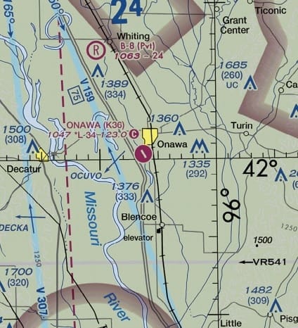
A) Yes, Onawa is in Class D airspace that is designated for an airport.
B) No, your entire flight is in Class G airspace.
C) Yes, you must contact the Onawa control tower to operate within 5 miles of the airport.
UA.I.B.K20 Preflight familiarization, inspection, and actions for aircraft operations. According to 14 CFR part 107, who is responsible for determining the performance of a small unmanned aircraft?
A. Remote pilot-in-command. [See 107.19. Learn the short version of this regulation. “If anything goes wrong, it is most likely the PIC’s fault.” You shouldn’t let anyone force you into flying somewhere or doing something you feel is unsafe. You are getting the whacking if anything goes wrong, not them.].
B. Manufacturer.
C. Owner or operator.
UA.I.B.K21a According to 14 CFR part 107, what is the maximum groundspeed for a small UA?
A) 87 knots. [87 knots is 100 MPH]
B) 87 mph.
C) 100 knots. [100MPH, not knots].
UA.I.B.K21b (Refer to FAA-CT-8080-2H, Figure 78.) You have been contracted to inspect towers located approximately 4NM southwest of the Sioux Gateway (SUX) airport operating an unmanned aircraft. What is the maximum altitude above ground level (AGL) that you are authorized to operate over the top of the towers?
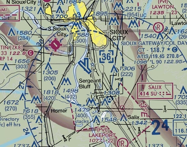
A) 400 Feet AGL.
B) 402 feet AGL.
C) 802 feet AGL. [This is Class D airspace and you would have to get a COA to operate here. I have NEVER seen one been given out for over 400ft. Yes, you could technically get a 400ft+ waiver and a COA to exercise it or get a special COA to operate within 400ft of a structure but it is extremely rare. Technically, under 107, if you are within 400ft of the structure you can go up to 400ft above the top of it (402 AGL is what the map says) which makes it 802 AGL.]
UA.I.B.K22 Upon request by the FAA, the remote pilot-in-command must provide
A) a logbook documenting small UA landing currency. [107.7 says, “Any other document, record, or report required to be kept under the regulations of this chapter.” The big word is required. Does 107 require a logbook? No. Is it smart to have? Yes.]
B) a remote pilot certificate with a small UAS rating. [107.7 Inspection, testing, and demonstration of compliance. (a) A remote pilot in command, owner, or person manipulating the flight controls of a small unmanned aircraft system must, upon request, make available to the Administrator: (1) The remote pilot certificate with a small UAS rating[.]”]
C) any employer issued photo identification.
UA.I.B.K25 When may a remote pilot reduce the intensity of an aircraft’s lights during a night flight?
A. At no time may the lights of an sUAS be reduced in intensity at night.
B. When a manned aircraft is in the vicinity of the sUAS. [This makes no sense. The lights are critical when manned aircraft are around.]
C. When it is in the interest of safety to dim the aircraft’s lights.
C. Remote Pilot Certification with an sUAS rating (*)
UA.I.C.K2 The refusal of a remote PIC to submit to a blood alcohol test when requested by a law enforcement officer
A) is grounds for suspension of revocation of their remote pilot certificate. [See 107.59]
B) can be delayed for a period up to 8 hours after the request.
C) has no consequences to the remote pilot certificate.
E. Operations Over People
UA.I.E.K3a To conduct Category 1 operations, a remote pilot in command must use a small unmanned aircraft that weighs
A. 0.55 pounds or less. [Correct.]
B. 0.65 pounds or less.
C. 0.75 pounds or less.
UA.I.E.K3d Which Category of small unmanned aircraft must have an airworthiness certificate issued by the FAA?
A. 4.
B. 3.
C. 2
F. Remote Identification (RID)
UA.I.F.K1 What must a person, who is manipulating the controls of a small unmanned aircraft, do if the standard remote identification fails during a flight?
A. Land the aircraft as soon as practicable.
B. Notify the nearest FAA Air Traffic facility.
C. Activate the aircraft’s navigation lights. [Drones are not even required to have navigation lights under 107]
Area II. Airspace Classification and Operating Requirements (Initial 15-25%)
A. Airspace Classification (*)
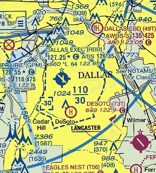
UA.II.A.K1a (Refer to FAA-CT-8080-2H, Figure 25, Area 3.) The floor of Class B airspace at Dallas Executive (RBD) is
A) at the surface.
B) 3,000 feet MSL. [Class B airports are huge up side down wedding cakes. The B overhangs the Class D airspace. If you see the Class D top says [-30]. The minus means up to but NOT including 3,000. Right near it you see the 110/30 which means Class B is 3,000-11,000 ft.
C) 3,100 feet MSL
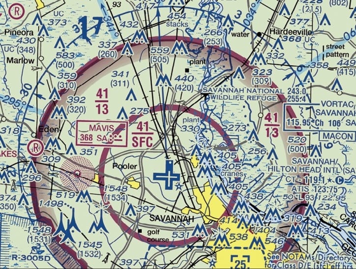
UA.II.A.K1b General airspace: Class C controlled airspace. (Refer to FAA-CT-8080-2H, Figure 23, area 3.) What is the floor of the Savannah Class C airspace at the shelf area (outer circle)?
A. 1,300 feet AGL. [It is NEVER AGL. There is a lot that can be said here, but if you want to know more, study out barometers and the different types of altitude.]
B. 1,300 feet MSL. [Remember the two zeros are chopped off. SFC means surface. Why is this important? Because you might need to do a job under the Class C shelf. If you don’t know this right off the top of your head, you are leaving money on the table. Remember that Class C operations require a waiver (COA). You need to be able to say quickly, “Yes, we can do that job” or “No, we can’t do that job and I’ll have to file a COA to fly in Class C airspace.” If you need help filing a COA in Class C, contact me.]
C. 1,700 feet MSL.
UA.II.A.K1b General airspace: Class C controlled airspace. According to 14 CFR part 107 the remote pilot in command (PIC) of a small unmanned aircraft planning to operate within Class C airspace
A. must use a visual observer. [Nope. Only Part 107 FPV racers or 44807 operators need a VO.]
B. is required to file a flight plan. [You don’t have to be on a flight plan to fly in Class C.]
C. is required to receive ATC authorization. [Bingo. Why? Because the FAA ATC wants to make sure you can fly in certain locations. Pro tip: Look at the runway of the Class C airport in Figure 23. The runways are North, South, East, and West. If you are flying in the “doughnut hole,” then you better know where the landing and departing traffic will be flying. Keep in mind that for some airports, especially at coastal airports, almost rarely use their northerly or southerly runways because the wind is almost always blowing east or west. You might be able to get a COA for those north or south areas of the airport easier. As always, if you need help getting one, contact me.]
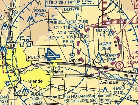
UA.II.A.K1c (This is a question I created). What type of airport is Pueblo Airport?
Class B
Class C
Class D
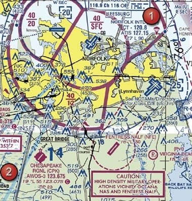
UA.II.A.K1d (Refer to FAA-CT-8080-2H, Figure 20, Area 1.) The Fentress NALF Airport (NFE) is in what type of airspace?
A) Class C.
B) Class E. [You can tell this based upon the dashed magenta line which indicated E at the surface.]
C) Class G.
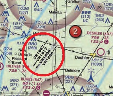
UA.II.A.K2 Special use within airspace. (Prohibited, restricted, warning, military operations, alert, and controlled firing.) (Refer to FAA-CT-8080-2H, Figure 59, area 2.) The chart shows a gray line with “VR1667, VR1617, VR1638, and VR1668.” Could this area present a hazard to the operations of a small UA?
A. No, all operations will be above 400 feet.
B. Yes, this is a Military Training Route from 1,500 feet AGL. [It is extremely important to know this so you can expect low-flying military helicopters flying this route. Some of which may be at 400ft or below. Here is what the AIM says: “(a) MTRs with no segment above 1,500 feet AGL must be identified by four number characters; e.g., IR1206, VR1207. (b) MTRs that include one or more segments above 1,500 feet AGL must be identified by three number characters; e.g., IR206, VR207.” What does this mean? They can ALWAYS be flying in your airspace.]
C. Yes, the defined route provides traffic separation to manned aircraft.
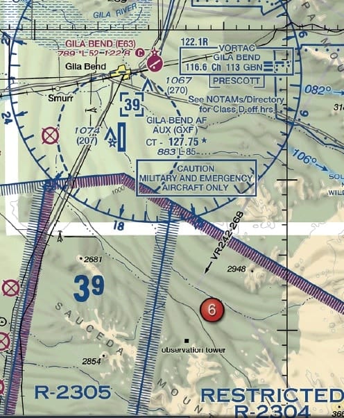
UA.II.A.K2 (Refer to FAA-CT-8080-2H, Figure 75, Area 6.) During preflight planning, you plan to operate in R-2305. Where would you find additional information regarding this airspace?
A) In the Aeronautical Information Manual. [This will have only general information, not specific.]
B) In the Charts Supplements U.S. [This is the best answer. I’m tired of getting emails about this. There is a section in the Chart Supplement for the Southwest for this specific restricted area. Yes, you could normally just look at the Special Use Airspace area of the chart and get info. Everyone studies using all of these other apps developed by people that are not FAA certificated flight instructors. Pull the SW Chart Supplement. You’ll see an entire section for R-2305. I’ll copy-paste it here. “A transit route extends from Gila Bend to the Eric Marcus Airport over Arizona Highway 85 at 500 feet above ground level (AGL). VFR rules govern civilian flight through the Goldwater Air Force Range. Airevac flights will be given priority over all other air traffic other than inflight emergencies. The Airevac call sign will be used only when the aircraft is on an actual air evacuation mission. Department of Public Safety (DPS) ‘‘Ranger’’ call signs must indicate they are on an Airevac mission to receive priority. Military aircraft will have priority over all remaining aircraft. Aircraft requesting to transition this airspace may encounter delays.General aviation aircraft must coordinate their route of flight, departure, and return times with Range Operations prior to departure. Phone (623) 856–8818/8819. Once airborne, aircraft from the north contact Gila Bend AFAF Tower (primary) on 257.65/127.75 (UHF/VHF) or Range Operations (secondary) on 264.125/122.775. Aircraft from the south contact Range Operations 264.125/122.775. Aircraft must hold outside restricted airspace until clearance is granted to transit the area. After receiving clearance into the Restricted Airspace, pilots shall monitor Range Operations frequency. The preferred VFR procedure will be to fly over Highway 85 at 500 feet AGL, monitoring Range Ops on VHF 122.775. At night aircraft will fly over Highway 85 at or below 1000 feet AGL. Military aircraft on manned ranges will be instructed to remain clear of Highway 85 or to transit the highway 500 feet above altitude of transiting aircraft. Caution: Due to repeater transmissions and mountainous terrain, flights north of the Sauceda Mountains (Black Gap) will normally only be able to contact Gila Bend Tower. Flights south of the mountains should contact Range Operations. Military aircraft on the Range may be operating lights out. The normal hours of the Goldwater Air Force Range are from 0630–2400 local Monday through Saturday. When the range is inactive, Gila Bend AFAF Tower and Range Operations are closed. When the range is active, Gila Bend AFAF Tower and Range Operations may be closed, and the transit route unavailable, Contact Albuquerque ARTCC on 126.45 or 125.25 to determine transit availability or request flight following.”]
C) In the Special Use Airspace area of the chart. [This is an answer but the chart supplement provides more information. The side portion of the sectional chart will give you information regarding altitudes, times, etc.]
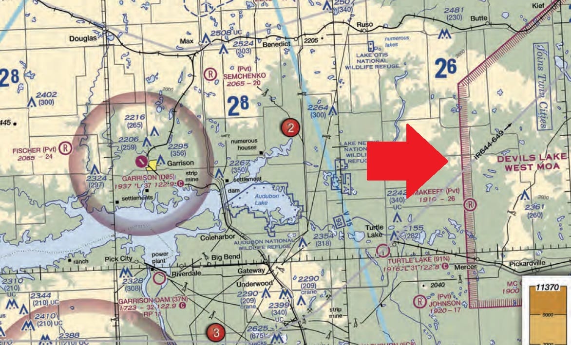
UA.II.A.K2 Special use within airspace. (Prohibited, restricted, warning, military operations, alert, and controlled firing.) (Refer to FAA-CT-8080-2H, Figure 21.) You have been hired by a farmer to use your small UA to inspect his crops. The area that you are to survey is in the Devil`s Lake West MOA, east of area 2. How would you find out if the MOA is active?
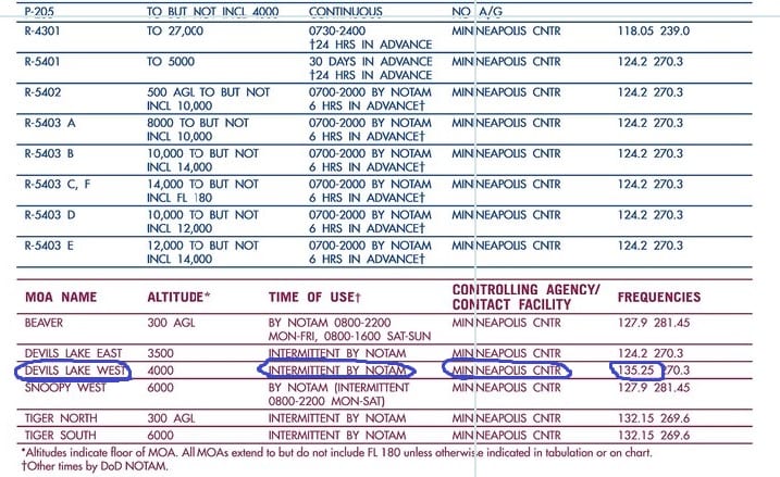
A. Refer to the legend for special use airspace phone number. [Ok. This answer is wrong. You won’t be getting any telephone numbers here. You’ll get VHF frequencies on the side of the map where the MOAs are listed. How do you find the MOAs on the side? This is annoying because most of you guys are using some type of digital map. This is how you find it on Skyvector. You make sure the sectional chart at the top right is clicked and then you move over all the way to the left and you’ll see a list of all the MOAs. This MOA is from 4000-17,999. For practice, let’s pretend that it goes all the way to the ground. We need to figure out if it is active. The 135.25 frequency won’t help because you’ll almost never get ahold of anyone with your handheld. This is how to figure out if it is active or not. You can either (1) Check to see if there is an active NOTAM on https://www.notams.faa.gov/dinsQueryWeb/which has its own MOA tab, (2) check on https://pilotweb.nas.faa.gov/PilotWeb/(3) call up 1-800-WX-BRIEF, or (4) call via phone the ARTCC over the area which would be Minneapolis Center. Here is the FAA web page to find the ARTCC phone numbers. If you are interested in setting up flight programs and want a more comprehensive set of guidelines that includes this information and more, contact me.]
B. This information is available in the Small UAS database. [What? I don’t know what this means. There is no such thing.]
C. In the Military Operations Directory. [No such thing.]
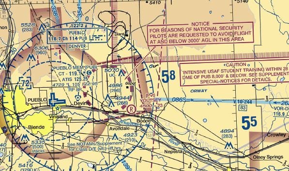
UA.II.A.K3 (This is a question I created). What is the dashed magenta line in a circle east of the Pueblo Airport represent?
A. Class E at the surface airspace.
B. This is an isogonic line. [While an isogonic is a dashed magenta line. It is a long dashed magenta line. You can actually see one in this picture just east of the national security area and Class E at the surface airspace. Notice all three answers are in this picture to show you the contrast.]
C. This is a national security area. [This is NOT Class E at the surface. The dashed circle is a national security area. The thinner dashed line in the shape of a box is Class E at the surface extension.]
UA.II.A.K3 Your surveying company is a title sponsor for a race team at the Indianapolis 500. To promote your new aerial surveying department, you decide to video part of the race using a small UA. The FAA has issued a Temporary Flight Restriction (TFR) for the race in the area you plan to fly. In this situation
A. you may fly your drone in the TFR since your company is sponsoring a team at the race. [No. Race sponsors or stadium owners, etc. don’t control the TFR.]
B. the TFR applies to all aircraft; you may not fly in the area without a Certificate of Waiver or Authorization. [Correct generally.].
C. flying your drone is allowed if you notify all non-participating people of the closed course UA operation.
B. Airspace Operational Requirements (*)
UA.II.B.K1 (Refer to FAA-CT-8080-2H, Figure 23, Area 4.) What is the required flight visibility for a remote pilot operating an unmanned aircraft near the Plantation Airport (JYL)?
A) 5 statute miles.
B) 1 statute mile.
C) 3 statute miles. [I think this is trying to confuse the manned aircraft guys because visibility for Class G operations for manned aircraft is 1 mile of visibility and 3 for E airspace (starts at 700ft AGL around Plantation). Part 107 has visibility at 3 SM of visibility.]
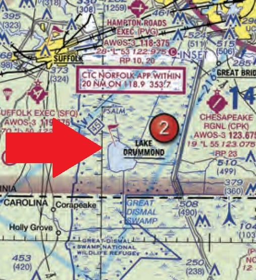
UA.II.B.K4 (Refer to FAA-CT-8080-2H, Figure 20, area 2.) Why would the small flag at Lake Drummond of the sectional chart be important to a remote pilot?
A— This is a VFR check point for manned aircraft, and a higher volume of air traffic should be expected there. [Lots of aircraft means greater chance for mid-air collision.]
B— This is a GPS check point that can be used by both manned and remote pilots for orientation.
C— This indicates that there will be a large obstruction depicted on the next printing of the chart.
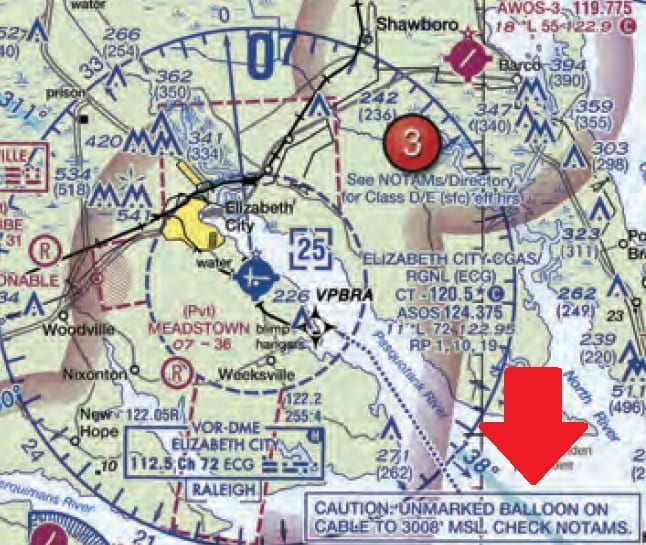
UA.II.B.K5 The NOTAM system including how to obtain an established NOTAM through Flight Service. (Refer to FAA-CT-8080-2H, Figure 20, area 5.) How would a remote PIC “CHECK NOTAMS” as noted in the CAUTION box regarding the unmarked balloon?
A. By utilizing the B4UFLY mobile application. [That would be a nice feature but I don’t know how much money the FAA will put into this app. That app is more like an airspace for dummies app. Learn how to read charts so you know where you can legally fly to make more money.]
B. By contacting the FAA district office. [Nope. However, you should reach out to meet with these guys sometime. Let them know you are trying to be compliant and professional. Better to “set the stage” with that than if they come after you and remember you as the guy who did _________.]
C. By obtaining a briefing via an online source such as: 1800WXBrief.com. [You could do this. I suggest reading my article on 5 Ways to Prove You Did a Pre-Flight Briefing.]
Area III. Weather (Initial 11-16%)
A. Sources of Weather
[METAR KLAX 121852Z 25004KT 6SM BR SCT007 SCT250 16/15 A2991 SPECI KMDW 121856Z 32005KT 1 1/2SM RA OVC007 17/16 A2980 RMK RAB35]UA.III.A.K2 Aviation routine weather reports (METAR). (Refer to FAA-CT-8080-2H, Figure 12.) What are the current conditions for Chicago Midway Airport (KMDW)?
A. Sky 700 feet overcast, visibility 1-1/2SM, rain. [Time, wind direction and speed, visibility in SM, clouds, Temperature/ dew point, altimeter in inches of mercury. It is almost always the same format. Just go through and find the two wrong answers.]
B. Sky 7000 feet overcast, visibility 1-1/2SM, heavy rain. [This can quickly be eliminated because it is always two zeros after the end for the altitude of the base of the clouds. It would be 700, not three zeros to make 7000.]
C. Sky 700 feet overcast, visibility 11, occasionally 2SM, with rain. [Clever. Really clever. Looking at the other material, like LAX above which shows 6SM, that should have clued you in that the value for that place should be a number in statute miles.
[SPECI KJFK 121853Z 18004KT 1/2SM FG R04/2200 OVC005 20/18 A3006]UA.III.A.K2 Aviation routine weather reports (METAR). (Refer to FAA-CT-8080-2H, Figure 12.) The wind direction and velocity at KJFK is from
A. 180° true at 4 knots. [This is how you remember if something is true or magnetic. “If it is in print, it must be true.” The only exceptions are for runways, VOR compass rose, and AWOS/ASOS headings when you call from a phone.]
B. 180° magnetic at 4 knots.
C. 040° true at 18 knots.
B. Effects of Weather on Performance
UA.III.B.K1a Weather theory: Density altitude. What effect does high density altitude have on the efficiency of a UA propeller?
A. Propeller efficiency is increased.
B. Propeller efficiency is decreased. [A high density altitude decreases the power output of a normal aspirated engine because there are less air molecules in the combustion. Most drones are electric so I’m taking this out of the equation. There are fewer air molecules flying over the wing (the propeller) which results in a decrease in lift.]
C. Density altitude does not affect propeller efficiency.
UA.III.B.K1c Weather theory: Atmospheric stability, pressure, and temperature. What are the characteristics of stable air?
A. Good visibility and steady precipitation. [It would be poor visibility].
B. Poor visibility and steady precipitation. [Yes! stratiform clouds, smooth air, poor visibility in haze and smoke, and continuous precipitation.]
C. Poor visibility and intermittent precipitation. [No intermittent is more like unstable air that creates cumulonimbus clouds]
UA.III.B.K1d Weather theory: Air masses and fronts. What are characteristics of a moist, unstable air mass?
A. Turbulence and showery precipitation. [Cumuliform clouds, turbulent air, good visibility, and showery precipitation are all characteristics of unstable air.]
B. Poor visibility and smooth air. [Poor visibility and smooth air are characteristics of stable air.]
C. Haze and smoke. [Haze and smoke are the causes of the poor visibility in stable air!]
UA.III.B.K1j Weather theory: Fog. You have received an outlook briefing from flight service through 1800wxbrief.com. The briefing indicates you can expect a low-level temperature inversion with high relative humidity. What weather conditions would you expect?
A. Smooth air, poor visibility, fog, haze, or low clouds. [A temperature inversion means some warm air on top of some cold air. The cold air underneath on the ground, along with a high relative humidity, means you are expecting fog in the cooler area. You should also check the METARS for the airports in the area as you will most likely have a temperature/dewpoint spread that is low. Example 12/10. The air will be smooth because there is little convection.]
B. Light wind shear, poor visibility, haze, and light rain. [The cold air underneath means you are not going to have much convection so light wind shear is a wrong answer.]
C. Turbulent air, poor visibility, fog, low stratus type clouds, and showery precipitation. [Once again, you are going to have very little convection because of the cold air.]
Area IV. Loading and Performance (Initial 7-11%)
A. Loading and Performance
UA.IV.A.K1b General loading and performance: Balance, stability, and center of gravity. To ensure that the unmanned aircraft center of gravity (CG) limits are not exceeded, follow the aircraft loading instructions specified in the
A. Pilot’s Operating Handbook or UAS Flight Manual. [I don’t know of any drone manufacturers who have created a manual which allows you to calculate the CG. Manned aviation manuals have ways you can calculate so you don’t exceed CG limits. I think some of the reasons why the drone manuals don’t have them are because (1) the manufacturers are “toy” manufacturers who know little about aerodynamics, (2) they don’t want to waste money on something that isn’t required, and (3) the drones they sell can’t carry any payload so the CG is static.]
B. Aeronautical Information Manual (AIM). [Great for general aviation info but bad for specific aircraft info.]
C. Aircraft Weight and Balance Handbook. [This looks like a great answer but it isn’t. This handbook is helpful for studying for the test but won’t tell you anything about your specific aircraft.]
UA.IV.A.K1b General loading and performance: Balance, stability, and center of gravity. A stall occurs when the smooth airflow over the unmanned airplane`s wing is disrupted, and the lift degenerates rapidly. This is caused when the wing
A. exceeds the maximum speed. [You won’t stall at this speed. Your wings will pop off because of drag.]
B. exceeds maximum allowable operating weight. [This isn’t true. You can fly somewhat overweight all day long (not legally), but it isn’t going to cause your wings to stall or pop off. We care about flying overweight in turbulent air or when doing abrupt maneuvers that can over stress the aircraft and break it. This is why we have maneuvering speed in manned aircraft so we know what speed to keep our aircraft below so we don’t break it in the event of a full control deflection because the aircraft will stall before it exceeds its category limits for what the aircraft was certificated for. There are no aircraft category G limits like manned aircraft. All Part 107 aircraft are not required to have an airworthiness certificate like manned aircraft. So flying a drone “overweight” isn’t the same as flying a certificated manned aircraft over the weight which might exceed category limits in a full control deflection.]
C. exceeds its critical angle of attack. [You aren’t going to be flying if you hit this angle no matter how fast you are going. Here is a great example of a Sukhoi Su-35 Russian jet doing the Cobra maneuver which exceeds its critical angle of attack. ]
UA.IV.A.K1a. The importance and use of performance data to predict the effect on the aircraft’s performance of an sUAS. When operating an unmanned airplane, the remote pilot should consider that the load factor on the wings may be increased anytime
A. the CG is shifted rearward to the aft CG limit. [This wouldn’t increase load factor. If the airplane uses an elevator for pitch, this would actually DECREASE load factor.]
B. the airplane is subjected to maneuvers other than straight and level flight.
C. the gross weight is reduced. [Gross weight reduction would DECREASE load factor.]
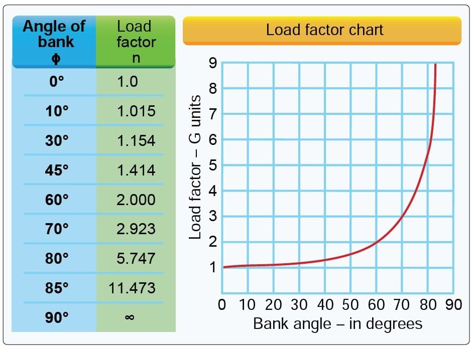
UA.IV.A.K1a.The importance and use of performance data to predict the effect on the aircraft’s performance of an sUAS. (Refer to FAA-CT-8080-2H, Figure 2.) If an unmanned airplane weighs 33 pounds, what approximate weight would the airplane structure be required to support during a 30° banked turn while maintaining altitude?
[Explanation: In a turn of 30 degrees of bank and while maintaining level flight (no altitude loss because you slightly pitched up), you will have a 1.154 load factor. This means that in this turn you will be feeling like you are pulling 1.154 G’s. 33 pounds x 1.154 = 38.082 pounds].A.34 pounds.
B. 47 pounds.
C. 38 pounds.
Area V. Operations (Initial 35-45%)
A. Radio Communications Procedures
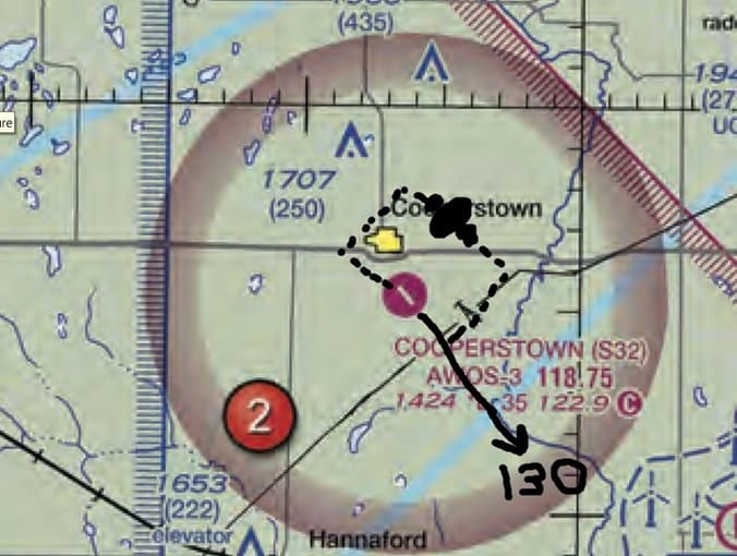
UA.V.A.K3 Recommended traffic advisory procedures. (such as: self-announcing of position and intentions by manned aviation operations and activities.) (Refer to FAA-CT-8080-2H, Figure 26, area 2.) While monitoring the Cooperstown CTAF you hear an aircraft announce that they are midfield left downwind to RWY 13. Where would the aircraft be relative to the runway?
A. The aircraft is East. [Runway 13 has a magnetic heading of 130. Keep in mind that our VFR sectionals are in true, not magnetic, but VORs and runway headings are magnetic. You know which way the airplane took off by looking at the runway orientation. The runways on the map tend to be pretty close to what they are in real life. The airport pattern in the U.S. goes to the left (because the captain or pilot tends to fly on that side and has a better view of the runway and it is the law). The exceptions to this are if ATC at a tower, visual markings or lights, AFD, or the sectional with an RP symbol next to the airport say otherwise. There is no RP on Cooperstown so it is left. So if airplanes are going left, you should fly on the right hand pattern side right? WRONG! Helicopters are required by law to avoid the flow of fixed-wing aircraft and tend to be lower.]
B. The aircraft is South.
C. The aircraft is West.
B. Airport Operations (*)
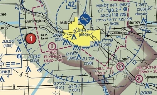
UA.V.B.K2 (Refer to FAA-CT-8080-2H, Figure 21, Area 1.) After receiving authorization from ATC to operate a small UA near Minot International airport (MOT) while the control tower is operational, which radio communication frequency could be used to monitor manned aircraft and ATC communications?
A) UNICOM 122.95
B) ASOS 118.725.
C) CT-118.2. [This is the control frequency and also is the CTAF frequency.]
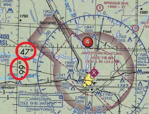
UA.V.B.K6a Sources for airport data: Aeronautical charts. (Refer to FAA-CT-8080-2H, Figure 21.) What airport is located approximately 47 (degrees) 40 (minutes) N latitude and 101 (degrees) 26 (minutes) W longitude?
A. Mercer County Regional Airport. [This is definitely not even close. This airport is in the low minutes of 47 degrees North.)
B. Semshenko Airport. [Ah yes, this is a close private airport. You can tell it is private because of the Pvt. Careful measurements will let you know that this is not the airport]
C. Garrison Airport. [Let’s make this simple. Ladder sounds kind of like latitude. You climb the ladder going north. (Keep in mind it is north only if you are in the Northern Hemisphere) For minutes, just think of them as tick marks. There is a box with 30 tick marks in it, a line, and then another 30 tick marks. In total, you get 60 minutes. For longitude, also called meridians, think of the Prime Meridians running through Greenwich, England. Why is this useful? To figure out if the coordinates of the potential job site are in airspace which requires a COA. I use coordinates all the time when I’m working with my clients to figure out if they need a COA or not. Can your attorney do that?]
UA.V.B.K6a Sources for airport data: Aeronautical charts. (Refer to FAA-CT-8080-2H, Figure 22, area 2.) At Coeur D`Alene which frequency should be used as a Common Traffic Advisory Frequency (CTAF) to monitor airport traffic?
A. 122.05 MHz. [This is the frequency to contact Boise Flight Service on.]
B. 135.075 MHz. [This is the AWOS, not the CTAF. You can check out the airport weather on this frequency. Would also be great to find out what the surface winds are blowing at that location.].
C. 122.8 MHz. [This is the CTAF].
UA.V.B.K6a (Refer to FAA-CT-8080-2H, Figure 20, Area 4.) A small UA is being launched 2 NM northeast of the town of Hertford. What is the height of the highest obstacle?
A) 399 feet MSL.
B) 500 feet MSL.
C) 500 feet AGL. [This is a very sneaky question. If you read carefully in the aeronautical chart user’s guide on page 12 it says, “Whenever possible, the FAA depicts specific obstacles on charts. However, in high-density areas like city complexes, only the highest obstacle is represented on the chart using the group obstacle symbol to maximize legibility.”]
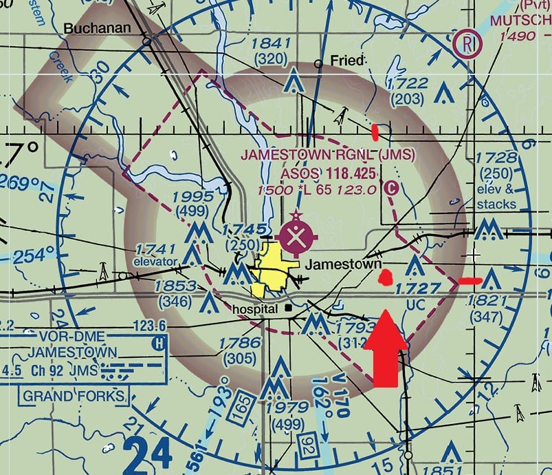
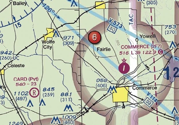
UA.V.B.K6a Sources for airport data: Aeronautical charts. (Refer to FAA-CT-8080-2H, Figure 26, area 4.) You have been hired to inspect the tower under construction at 46.9N and 98.6W, near Jamestown Regional (JMS). What must you receive prior to flying your unmanned aircraft in this area?
A. Authorization from the military. [This isn’t military airspace.]
B. Authorization from ATC. [This is Class E airspace going to the surface ASSOCIATED with an airport. The magenta dashes indicate this. Read my article on 107.41 for an in-depth discussion on E-extensions and E associated with an airport. The magenta halo indicates Class E airspace starts at 700ft. To convert to decimal points, you divide 60 (The number of tick marks per degree. Remember there are 30 tic marks per quadrant but two quadrants make up a degree.) by 10 and you’ll get 6 tick marks per .1 According to Part 107, you’ll need authorization to operate within Class E at the surface airspace. ]
C. Authorization from the National Park Service. [There is no national park here.]
![]()
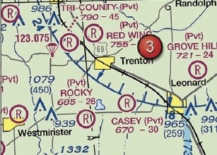
UA.V.B.K6a (Refer to FAA-CT-8080-2H, Figure 24, Area 3, and Legend 1.) For information about the parachute operations at Tri-County Airport, refer to
A) notes on the border of the chart.
B) Chart Supplements U.S. [The parachute sign is next to the airport. Legend 1 clues you in to look at the chart supplement even.]
C) the Notices to Airmen (NOTAM) publication.
UA.V.B.K6a (Refer to FAA-CT-8080-2H, Figure 78. Near the center of the figure.) What class of airspace is associated with SIOUX GATEWAY/COL DAY (SUX) Airport?
A) Class B airspace.
B) Class C airspace.
C) Class D airspace. [This is evidenced by the blue dashes. Technically, it also have some E at the surface airspace extensions which are marked by the dashed magenta lines.]
UA.V.B.K6a (Refer to FAA-CT-8080-2H, Figure 24, Area 6.) What type of airport is Card Airport?
A) Public towered.
B) Public non-towered.
C) Private non-towered. [It is private because it has a big R on it. You can tell it is not towered because it is magenta and not blue.]
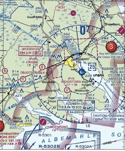
UA.V.B.K6a Sources for airport data: Aeronautical charts. (Refer to FAA-CT-8080-2H, Figure 20, area 3.) With ATC authorization, you are operating your small unmanned aircraft approximately 4 SM southeast of Elizabeth City Regional Airport (ECG). What hazard is indicated to be in that area?
A. High density military operations in the vicinity.
B. Unmarked balloon on a cable up to 3,008 feet AGL. [It says MSL right on the sectional. Even if it didn’t, it would have to be MSL because pilots flying don’t have an accurate way of determining AGL and are using their aneroid barometers which is trying to put out an indicated altitude ball parkish to MSL.]
C. Unmarked balloon on a cable up to 3,008 feet MSL. [Keep in mind that if you are flying 4SM from the airport, you are within 4 nautical miles from the airport. Class D airports generally have a radius of 4NM. You would need an airspace waiver to operate in this area. Contact me if you need one! ]
UA.V.B.K6a Sources for airport data: Aeronautical charts. (Refer to FAA-CT-8080-2H, Figure 26.) What does the line of latitude at area 4 measure?
A. The degrees of latitude east and west of the Prime Meridian. [This is partially true. It is correct to say degrees of latitude but incorrect to say west. Latitude goes north & south like you are climbing a latter.]
B. The degrees of latitude north and south from the equator. [Like you are climbing a later going up or down. Just remember which hemisphere you are in. 99% of you guys aren’t going below the equator so it will be north most of the time.]
C. The degrees of latitude east and west of the line that passes through Greenwich, England. [Just answer A repackaged.]
UA.V.B.K6b Sources for airport data: Chart Supplements U.S. (formerly Airport/facility directory) The most comprehensive information on a given airport is provided by
A. the Chart Supplements U.S. (formerly Airport Facility Directory). [This will tell you all sorts of things such as the phone number to the airport manager.]
B. Notices to Airmen (NOTAMS). [Um no. These will tell you SOME things about the airport.]
C. Terminal Area Chart (TAC). [This map is a 2x zoomed in version of the sectional.]
C. Emergency Procedures (*)
UA.V.C.K1 Emergency planning and communication. When using a small UA in a commercial operation, who is responsible for briefing the participants about emergency procedures?
A. The FAA inspector-in-charge. [Um. No. The FAA inspector is the person who investigates your goof up.]
B. The lead visual observer. [Nope. But this person is great for doing the “coffee & doughnuts” briefing.]
C. The remote PIC. [Bingo! Being the pilot in command means you are responsible. Period. For everything. For example, if you don’t properly brief your VO and a FAA inspector ramp checks and the VO doesn’t know what is going on, you get in trouble. It’s like being at the bottom of a gutter, all the garbage will flow your way.]
UA.V.C.K1 Emergency planning and communication. To avoid a possible collision with a manned airplane, you estimate that your small UA climbed to an altitude greater than 600 feet AGL. To whom must you report the deviation?
A. Air Traffic Control. [If you are flying without an airspace waiver, 600ft isn’t even in controlled airspace so you wouldn’t be contacting ATC. It might be wise to just quickly mention on the CTAF where you are if you were flying near a Class G airport and you had to do an emergency deviation up to 600ft.]
B. The National Transportation Safety Board. [See What Do I Do After a Drone Crash?]
C. Upon request of the Federal Aviation Administration. [See What Do I Do After a Drone Crash?]
UA.V.C.K2 What precautions should a remote PIC do to prevent possible inflight emergencies when using lithium-based batteries?
A) Store the batteries in a freezer to allow proper recharging. [Cold temperature really goofs up charging and use of LIPO batteries. It would have been better for them to create a risk question and highlight that your flight times using a cold LIPO batter are much lower than in warmer conditions.]
B) Follow the manufacturer`s recommendations for safe battery handling. [This is a “No-duh” type of answer.]
C) Allow the battery to charge until it reaches a minimum temperature of 100 ° [If CHARGING is making your batteries really warm, you should stop and try and figure out why they are getting this hot as you might have some type of failure that might lead to a failure. You also should consider charging your batteries in a safe place where if they catch on fire, you don’t goof up everything.]
D. Aeronautical Decision-Making (*)
UA.V.D.K1 Aeronautical Decision Making (ADM). Safety is an important element for a remote pilot to consider prior to operating an unmanned aircraft system. To prevent the final “link” in the accident chain, a remote pilot must consider which methodology?
A. Crew Resource Management. [“Crew resource management (CRM). The application of team management concepts in the flight deck environment. It was initially known as cockpit resource management, but as CRM programs evolved to include cabin crews, maintenance personnel, and others, the phrase “crew resource management” was adopted. This includes single pilots, as in most general aviation aircraft. Pilots of small aircraft, as well as crews of larger aircraft, must make effective use of all available resources; human resources, hardware, and information. A current definition includes all groups routinely working with the flight crew who are involved in decisions required to operate a flight safely. These groups include, but are not limited to pilots, dispatchers, cabin crewmembers, maintenance personnel, and air traffic controllers. CRM is one way of addressing the challenge of optimizing the human/machine interface and accompanying interpersonal activities.”]
B. Safety Management System. [“SMS is the formal, top-down, organization-wide approach to managing safety risk and assuring the effectiveness of safety risk controls. It includes systematic procedures, practices, and policies for the management of safety risk.”]
C. Risk Management. [This is the part of the decision making process which relies on situational awareness, problem recognition, and good judgment to reduce risks associated with each flight.]
UA.V.D.K1 Aeronautical Decision Making (ADM). A local TV station has hired a remote pilot to operate their small UA to cover breaking news stories. The remote pilot has had multiple near misses with obstacles on the ground and two small UAS accidents. What would be a solution for the news station to improve their operating safety culture?
A. The news station should implement a policy of no more than five crashes/incidents within 6 months. [But why 5? 5 crashes a year? A month? This is just a standard with no data behind it.]
B. The news station does not need to make any changes; there are times that an accident is unavoidable. [There is not enough information to know they do not need to make any changes. Maybe they have identified all the risks and attempted to mitigate them. Generally, you could and should be trying to do something to increase safety.]
C. The news station should recognize hazardous attitudes and situations and develop standard operating procedures that emphasize safety. [The hazardous attitudes would be an easy fix with the crew to help identify any hazards in the group. The SOP helps prevent pilots from forgetting things. SOPs are great at managing risk. What gets measured gets managed. There needs to be data gathered after the flights to find out how to best optimize the SOPs. Over time, the SOPs will be improved by identifying risks, implementing mitigations in the SOPs to counter those risks, and measuring the effectiveness of those mitigations. SOPs aren’t stagnant.]
UA.V.D.K2 Crew Resource Management (CRM). When adapting crew resource management (CRM) concepts to the operation of a small UA, CRM must be integrated into
A. the flight portion only. [This is wrong because the pre-flight portion and post flight portion need attention also for safety. Who checked on TFRs, weather, etc? Who charged the batteries? Who is going to charge the batteries and log the before and after voltages?]
B. all phases of the operation. [“All groups routinely working with the flight crew who are involved in decisions required to operate a flight safely. These groups include, but are not limited to pilots, dispatchers, cabin crewmembers, maintenance personnel, and air traffic controllers.”]
C. the communications only. [Nope. Into everything when people are involved.]
UA.V.D.K2 When a remote pilot-in-command and a visual observer define their roles and responsibilities prior to and during the operation of a small UA is a good use of
A) Crew Resource Management. [CRM is really the effective use of all available resources: human, hardware, and information. This is highlighting the human portion.]
B) Authoritarian Resource Management. [This isn’t even an FAA term.]
C) Single Pilot Resource Management [This doesn’t even make sense in light of this question.]
UA.V.D.K4 Hazardous attitudes. Identify the hazardous attitude or characteristic a remote pilot displays while taking risks in order to impress others?
A. Impulsivity. [This is doing something quickly without thinking it out.]
B. Invulnerability. [This is doing something dumb but you think an accident won’t happen to you. Please see the many dumb people on Youtube flying their aircraft over streets in urban areas.]
C. Macho. [You act macho to impress others.]
UA.V.D.K4 Hazardous attitudes. You have been hired as a remote pilot by a local TV news station to film breaking news with a small UA. You expressed a safety concern and the station manager has instructed you to “fly first, ask questions later.” What type of hazardous attitude does this attitude represent?
A. Machismo. [It isn’t this one because you aren’t trying to prove yourself to be awesome.]
B. Invulnerability. [Close. But it isn’t right. Invulnerability recognizes that the accident CAN happen, “but not to me.” Here there is NO recognition of the possibility of an accident being possible.]
C. Impulsivity. [From PHAK, “This is the attitude of people who frequently feel the need to do something, anything, immediately. They do not stop to think about what they are about to do, they do not select the best alternative, and they do the first thing that comes to mind.”]
E. Physiology
UA.V.E.K2 Drugs and alcohol use. Which is true regarding the presence of alcohol within the human body?
A small amount of alcohol increases vision acuity. [No, you may think that but it isn’t true.]
B. Consuming an equal amount of water will increase the destruction of alcohol and alleviate a hangover. [No, it just means you are going to be a drunk who has to go to the bathroom.]
C. Judgment and decision-making abilities can be adversely affected by even small amounts of alcohol. [Yes, being drunk can result in all sorts of poor life choices such as getting involved in Pokemon.
UA.V.E.K5 Stress and fatigue. You are a remote pilot for a co-op energy service provider. You are to use your UA to inspect power lines in a remote area 15 hours away from your home office. After the drive, fatigue impacts your abilities to complete your assignment on time. Fatigue can be recognized.
A. easily by an experienced pilot. [An experienced pilot should recognize that fatigue can creep up on them and they shouldn’t trust themselves.]
B. as being in an impaired state. [You should give your body proper rest so as to function optimally. Commercial pilots have rest requirements for a reason. You should also.]
C. by an ability to overcome sleep deprivation. [This isn’t fatigue. This is Redbull.]
UA.V.E.K6 Factors affecting vision. Which technique should a remote pilot use to scan for traffic? A remote pilot should
A. systematically focus on different segments of the sky for short intervals. [From the AIM 8−1−6. (c), “Because the eyes can focus only on this narrow viewing area, effective scanning is accomplished with a series of short, regularly spaced eye movements that bring successive areas of the sky into the central visual field. Each movement should not exceed 10 degrees, and each area should be observed for at least 1 second to enable detection. Although horizontal back-and-forth eye movements seem preferred by most pilots, each pilot should develop a scanning pattern that is most comfortable and then adhere to it to assure optimum scanning.]
B. concentrate on relative movement detected in the peripheral vision area. [Bad idea. From AC 90-48D 4.2.5, “It is essential to remember, however, that if another aircraft appears to have no relative motion, it is likely to be on a collision course with you. If the other aircraft shows no lateral or vertical motion, but is increasing in size, take immediate evasive action.”]
C. continuously scan the sky from right to left. [What about up and down also!? Additionally, you need some time to focus on a particular segment of sky.]
UA.V.E.K8 When preparing for a night flight, what should an sUAS pilot be aware of after assembling and conducting a preflight of an aircraft while using a bright flashlight or work light?
A. Once adapted to darkness, a persons eyes are relatively immune to bright lights. [Not true].
B. It takes approximately 30 minutes for a persons eyes to fully adapt to darkness. [Correct.]
C. The person should use a flash light equipped with LED lights to facilitate their night vision. [Not a good answer. Maybe if the LEDs were red LEDs that protect night vision but this is just too broad.]
F. Maintenance and Inspection Procedures (*)
UA.V.F.K1 Basic maintenance. Under what condition should the operator of a small UA establish scheduled maintenance protocol?
A. When the manufacturer does not provide a maintenance schedule. [Yes, because you should know what the mean time between failures is or have an idea on what are the typical problems certain drones encounter so you can PREVENT crashes.]
B. UAS does not need a required maintenance schedule. [I can hear it now from some of the droners “Maintenance…..We don’t need no stinkin maintenance.”]
C. When the FAA requires you to, following an accident. [It is cheaper to do maintenance on the front end rather than on the pieces on the backend.]
UA.V.F.K1 What actions should the operator of an sUAS do if the manufacturer does not provide information about scheduled maintenance?
A) The operator should contact the FAA for a minimum equipment list. [The reason the FAA delegated inspecting the drone to the remote pilot in command is the FAA can’t keep up to speed on the drones. They aren’t going to have some MEL.]
B) The operator should establish a scheduled maintenance protocol. [If you read AC 107-2 you would see they had a whole section on maintenance which should have clued you into this being a potential candidate for the correct answer]
C) The operator should contact the NTSB for component failure rates for their specific sUAS. [I guess you could do this but it seems like B is a way better answer.]
UA.V.F.K2 Preflight inspection. According to 14 CFR part 107, the responsibility to inspect the small UAS to ensure it is in a safe operating condition rests with the
A. remote pilot-in-command. [107.19 says, “(b) The remote pilot in command is directly responsible for and is the final authority as to the operation of the small unmanned aircraft system. (c) The remote pilot in command must ensure that the small unmanned aircraft will pose no undue hazard to other people, other aircraft, or other property in the event of a loss of control of the aircraft for any reason” How are you going to do that without doing an inspection on the aircraft and being familiar with it? § 107.49 says, “(c) Ensure that all control links between ground control station and the small unmanned aircraft are working properly; (d) If the small unmanned aircraft is powered, ensure that there is enough available power for the small unmanned aircraft system to operate for the intended operational time; and (e) Ensure that any object attached or carried by the small unmanned aircraft is secure and does not adversely affect the flight characteristics or controllability of the aircraft.” ]
B. visual observer. [No responsibility here but it would be smart to have the VO checking things also.]
C. owner of the small UAS. [Smart but not required.]
Frequently Asked Questions
Is the Part 107 test hard?
If you are a manned aircraft pilot, not that much. If you are brand new to aviation, it could be a steep learning curve especially for the aeronautical charts.
What score do you need to pass Part 107?
For the initial remote pilot knowledge exam you need a minimum of 70%.
How much does a Part 107 test cost?
The cost is around $175. Some organizations such as AOPA may provide a discount.
I hoped this helped guys. If you are needing legal help, don’t hesitate to contact me.
Aviation Attorney. FAA Certificated Commercial Pilot and Flight Instructor (CFI/CFII). Contributor at Forbes.com for Aerospace and Defense.